|
|
Antenna Structure Registration 1005877 |
 |
Registration Info | Registration Number: 1005877 |
| File Number: A1099930 |
| Status: Constructed |
| Date Constructed: 01/01/1949 |
| FAA EMI: N |
| NEPA: N |
Structure Info
| Structure Type: 6TA4 |
| Structure Coordinates: 43-27-41.0 N 83-48-49.0 W (NAD 83) |
| Structure Coordinates: 43-27-40.9 N 83-48-49.1 W (Converted to NAD 27) |
| Structure Address: 7225 Uncle Henry Rd |
| Structure City: Saginaw, MI |
| Structure County: Saginaw County |
| Painting & Lighting Info |
FCC Paragraph(s): 1, 3, 12, 21 |
| Elevation Info |
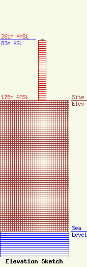
Site Elevation: 178 meters (584 ft) |
| Height of Structure: 82 meters (269 feet) |
| Overall Height Above Ground: 83 meters (272 feet) |
| Overall Height Above Mean Sea Level: 261 meters (856 feet) |
| Owner Info | Vertical Bridge S3 Assets, LLC
750 Park of Commerce Dr.
Boca Ratonq, FL 33487
(561) 406-4015
FCC-FAA@verticalbridge.com |
| Contact Info | Vertical Bridge S3 Assets, LLC
750 Park of Commerce Dr.
Boca Ratonq, FL 33487
Richard Hickey
(561) 406-4015
FCC-FAA@verticalbridge.com |
