|
|
Antenna Structure Registration 1007114 |
 |
Registration Info | Registration Number: 1007114 |
| File Number: A1297276 |
| FAA Study: 88-AWP-938-OE |
| FAA Issue Date: 05/23/1989 |
| Status: Constructed |
| Date Constructed: 01/01/1989 |
| NEPA: N |
Structure Info
|
| Structure Coordinates: 21-23-52.0 N 158-6-0.0 W (NAD 83) |
| Structure Coordinates: 21-24-03.4 N 158-06-09.9 W (Converted to NAD 27) |
| Structure Address: 4.8 Km Ne Of Nanakuli |
| Structure City: Palehua, HI |
| Structure County: Honolulu County |
| Painting & Lighting Info |
FAA Chapters: NONE |
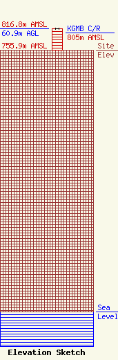
| Elevation Info |
Site Elevation: 755.9 meters (2480 ft) |
| Height of Structure: 60.9 meters (200 feet) |
| Overall Height Above Ground: 60.9 meters (200 feet) |
| Overall Height Above Mean Sea Level: 816.8 meters (2680 feet) |
| KGMB C/R Height Above Mean Sea Level: 805 meters (2641 ft)
|
| Owner Info | Gray Local Media, Inc.
4370 Peachtree Road, NE
Atlanta, GA 30319
(404) 266-8333
legalnotices@graymedia.com |
| Contact Info | Gray Local Media, Inc.
4370 Peachtree Road NE
Atlanta, GA 30319
Engineering Department
(404) 266-8333
legalnotices@graymedia.com |
