|
|
Antenna Structure Registration 1007337 |
 |
Registration Info | Registration Number: 1007337 |
| File Number: A1114836 |
| FAA Study: 2006-AGL-4040-OE |
| FAA Issue Date: 06/06/2006 |
| Status: Constructed |
| Date Constructed: 10/26/2006 |
| FAA EMI: N |
| NEPA: N |
Structure Info
| Structure Type: 9TA6 |
| Structure Coordinates: 42-13-52.0 N 83-11-53.0 W (NAD 83) |
| Structure Coordinates: 42-13-51.9 N 83-11-53.3 W (Converted to NAD 27) |
| Structure Address: 3700 Hazel (twr 6) |
| Structure City: Lincoln Park, MI |
| Structure County: Wayne County |
| Painting & Lighting Info |
FAA Chapters: NONE |
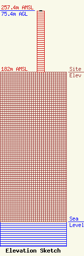
| Elevation Info |
Site Elevation: 182 meters (597 ft) |
| Height of Structure: 74.4 meters (244 feet) |
| Overall Height Above Ground: 75.4 meters (247 feet) |
| Overall Height Above Mean Sea Level: 257.4 meters (844 feet) |
| Owner Info | Salem Communications Holding Corporation
4880 Santa Rosa Road
Camarillo, CA 93012
(805) 987-0400
Scott.Foster@salemmedia.com |
| Contact Info | Salem Media Group, Inc
4880 Santa Rosa Road
Camarillo, CA 93012
(805) 384-4502
Scott.Foster@salemmedia.com |
