|
|
Antenna Structure Registration 1008595 |
 |
Registration Info | Registration Number: 1008595 |
| File Number: A1153286 |
| FAA Study: 2007-ANM-2127-OE |
| FAA Issue Date: 09/07/2007 |
| Status: Constructed |
| Date Constructed: 03/13/1995 |
| FAA EMI: N |
| NEPA: N |
Structure Info
| Structure Type: TOWER |
| Structure Coordinates: 42-43-25.0 N 105-18-24.0 W (NAD 83) |
| Structure Coordinates: 42-43-25.1 N 105-18-22.1 W (Converted to NAD 27) |
| Structure Address: 3.72 Mi Se |
| Structure City: Douglas, WY |
| Structure County: Converse County |
| Painting & Lighting Info |
FAA Circular #: 70/7460-1K |
FAA Chapters: 4, 8, 12 |
Remarks: OM&L to remain the same as prior study = A MED-DUAL SYSTEM |
Remarks: PRIOR STUDY 2007-ANM-1223-OE |
Remarks: OM&L to remain the same as prior study = A MED-DUAL SYSTEM |
| Elevation Info |
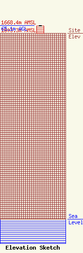
Site Elevation: 1603.3 meters (5260 ft) |
| Height of Structure: 61 meters (200 feet) |
| Overall Height Above Ground: 65.1 meters (214 feet) |
| Overall Height Above Mean Sea Level: 1668.4 meters (5474 feet) |
| K29JO-D C/R Height Above Mean Sea Level: 1613 meters (5292 ft)
|
| Owner Info | Cellco Partnership
5055 North Point Pkwy
Alpharetta, GA 30022
(770) 797-1070
Network.Regulatory@verizonwireless.com |
| Contact Info | Cellco Partnership
5055 North Point Pkwy
Alpharetta, GA 30022
Regulatory Manager
(770) 797-1070
Network.Regulatory@verizonwireless.com |
