|
|
Antenna Structure Registration 1010023 |
 |
Registration Info | Registration Number: 1010023 |
| File Number: A1137268 |
| FAA Study: 2016-ASW-4406-OE |
| FAA Issue Date: 10/06/2016 |
| Status: Constructed |
| Date Constructed: 06/27/2017 |
| NEPA: N |
Structure Info
| Structure Type: GTOWER |
| Structure Coordinates: 35-24-54.2 N 97-30-38.1 W (NAD 83) |
| Structure Coordinates: 35-24-54.0 N 97-30-37.0 W (Converted to NAD 27) |
| Structure Address: 5005 S Shields Blvd |
| Structure City: Oklahoma City, OK |
| Structure County: Oklahoma County |
| Painting & Lighting Info |
FAA Circular #: 70/7460-1L |
FAA Chapters: 3, 4, 5, 12 |
Remarks: PRIOR STUDY 1987-ASW-33-OE |
| Elevation Info |
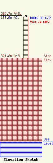
Site Elevation: 371.8 meters (1220 ft) |
| Height of Structure: 182.8 meters (600 feet) |
| Overall Height Above Ground: 188.9 meters (620 feet) |
| Overall Height Above Mean Sea Level: 560.7 meters (1840 feet) |
| KUOK-CD C/R Height Above Mean Sea Level: 540.7 meters (1774 ft)
|
| Owner Info | Tyler Enterpirses L.L.C.
5101 S. Shields Blvd
Oklahoma City, OK 73129
(405) 429-5003
TY@TYLERMEDIA.COM |
| Contact Info | Tyler Enterpises L.L.C.
5101 S. Shields Blvd.
Oklahoma City, OK 73129
Ty Tyler
(405) 429-5003
TY@TYLERMEDIA.COM |
