|
|
Antenna Structure Registration 1010731 |
 |
Registration Info | Registration Number: 1010731 |
| File Number: A1054942 |
| FAA Study: 95-ASO-1960-OE |
| FAA Issue Date: 09/05/1995 |
| Status: Constructed |
| Date Constructed: 07/30/1997 |
| FAA EMI: Y |
| NEPA: N |
Structure Info
| Structure Type: TOWER |
| Structure Coordinates: 18-10-4.0 N 66-34-37.0 W (NAD 83) |
| Structure Coordinates: 18-10-11.1 N 66-34-38.4 W (Converted to NAD 27) |
| Structure Address: Atop Monte Jayuya |
| Structure City: Jayuya, PR |
| Structure County: Ponce Municipio |
| Painting & Lighting Info |
FAA Circular #: 70/7460-1H |
FAA Chapters: 3, 4, 5, 13 |
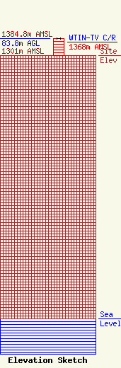
| Elevation Info |
Site Elevation: 1301 meters (4268 ft) |
| Height of Structure: 83 meters (272 feet) |
| Overall Height Above Ground: 83.8 meters (275 feet) |
| Overall Height Above Mean Sea Level: 1384.8 meters (4543 feet) |
| WTIN-TV C/R Height Above Mean Sea Level: 1368 meters (4488 ft)
|
| Owner Info | Televicentro of Puerto Rico, LLC
c/o Hemisphere Media Group, Inc.
Coral Gables, FL 33146
(305) 421-6334
atolston@hemispheretv.com |
| Contact Info | Lerman Senter PLLC
2001 L Street, NW
Washington, DC 20036
Laura Berman
(202) 429-8970
lberman@lermansenter.com |
