|
|
Antenna Structure Registration 1012934 |
 |
Registration Info | Registration Number: 1012934 |
| File Number: A1063856 |
| FAA Study: 96-ACE-1434-OE |
| FAA Issue Date: 01/06/1997 |
| Status: Constructed |
| Date Constructed: 01/01/1957 |
| FAA EMI: N |
| NEPA: N |
Structure Info
| Structure Type: TOWER |
| Structure Coordinates: 38-41-30.0 N 92-5-45.0 W (NAD 83) |
| Structure Coordinates: 38-41-29.9 N 92-05-44.3 W (Converted to NAD 27) |
| Structure Address: .25 Mi. W Of Hwy. 54 |
| Structure City: Holts Summit, MO |
| Structure County: Callaway County |
| Painting & Lighting Info |
FAA Circular #: 70/7460-1J |
FAA Chapters: 3, 4, 5, 13 |
| Elevation Info |
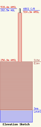
Site Elevation: 256.9 meters (843 ft) |
| Height of Structure: 260.5 meters (855 feet) |
| Overall Height Above Ground: 282.5 meters (927 feet) |
| Overall Height Above Mean Sea Level: 539.4 meters (1770 feet) |
| KRCG C/R Height Above Mean Sea Level: 530.3 meters (1740 ft)
|
| Owner Info | KRCG Licensee, LLC
Pillsbury Winthrop Shaw Pittman LLP
Washington, DC 20036
(202) 663-8195
miles.mason@pillsburylaw.com |
| Contact Info | KRCG Licensee, LLC
Pillsbury Winthrop Shaw Pittman LLP
Washington, DC 20036
(202) 663-8195
miles.mason@pillsburylaw.com |
