|
|
Antenna Structure Registration 1013180 |
 |
Registration Info | Registration Number: 1013180 |
| File Number: A1286295 |
| FAA Study: 2023-ASW-7250-OE |
| FAA Issue Date: 06/27/2023 |
| Status: Constructed |
| Date Constructed: 10/08/1997 |
| NEPA: N |
Structure Info
| Structure Type: GTOWER |
| Structure Coordinates: 30-19-23.8 N 97-47-59.5 W (NAD 83) |
| Structure Coordinates: 30-19-23.1 N 97-47-58.5 W (Converted to NAD 27) |
| Structure Address: 5319 Buckman Mountain Road (7000) |
| Structure City: Austin, TX |
| Structure County: Travis County |
| Painting & Lighting Info |
FAA Circular #: 70/7460-1H |
FAA Chapters: 3, 4, 5, 13 |
Remarks: OM&L to remain the same as prior study = PAINT/RED LIGHTS |
Remarks: PRIOR STUDY 2005-ASW-2955-OE |
Remarks: OM&L to remain the same as prior study = PAINT/RED LIGHTS |
Remarks: PRIOR STUDY 2005-ASW-2955-OE |
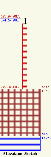
| Elevation Info |
Site Elevation: 249.3 meters (818 ft) |
| Height of Structure: 345.3 meters (1133 feet) |
| Overall Height Above Ground: 374.6 meters (1229 feet) |
| Overall Height Above Mean Sea Level: 623.9 meters (2047 feet) |
| Owner Info | American Towers LLC
10 Presidential Way
Woburn, MA 01801
(781) 926-4500
faa-fcc@americantower.com |
| Contact Info | American Towers LLC
10 Presidential Way
Woburn, MA 01801
(781) 926-4500
faa-fcc@americantower.com |
