|
|
Antenna Structure Registration 1014132 |
 |
Registration Info | Registration Number: 1014132 |
| File Number: A0016921 |
| FAA Study: 86-AGL-2230-OE |
| FAA Issue Date: 03/24/1988 |
| Status: Constructed |
| Date Constructed: 01/01/1980 |
| NEPA: N |
Structure Info
| Structure Type: TOWER |
| Structure Coordinates: 39-12-1.0 N 84-31-22.0 W (NAD 83) |
| Structure Coordinates: 39-12-00.8 N 84-31-22.2 W (Converted to NAD 27) |
| Structure Address: .12 Mi Sw Of Bend Rd & Winton Rd |
| Structure City: Cincinnati, OH |
| Structure County: Hamilton County |
| Painting & Lighting Info |
FCC Paragraph(s): B, D, H, 3, 6, 15, 21, 23 |
| Elevation Info |
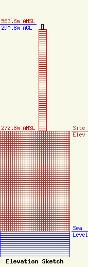
Site Elevation: 272.8 meters (895 ft) |
| Height of Structure: 277 meters (909 feet) |
| Overall Height Above Ground: 290.8 meters (954 feet) |
| Overall Height Above Mean Sea Level: 563.6 meters (1849 feet) |
| Owner Info | WSTR LICENSEE INC DBA = WSTR TV
2000 W 41ST ST
BALTIMORE, MD 21211
(410) 662-1412
|
