|
|
Antenna Structure Registration 1015747 |
 |
Registration Info | Registration Number: 1015747 |
| File Number: A1087677 |
| FAA Study: 96-AWP-3341-OE |
| FAA Issue Date: 02/12/1997 |
| Status: Constructed |
| Date Constructed: 11/28/1995 |
| FAA EMI: N |
| NEPA: N |
Structure Info
| Structure Type: TOWER |
| Structure Coordinates: 33-28-51.0 N 117-11-1.0 W (NAD 83) |
| Structure Coordinates: 33-28-50.9 N 117-10-57.9 W (Converted to NAD 27) |
| Structure Address: 2.5 Mi W Of Int Us15 And Sr79 |
| Structure City: Temecula, CA |
| Structure County: Riverside County |
| Painting & Lighting Info |
FAA Chapters: NONE |
Remarks: Removed expiration date from determination. Scenario 1./jjs/case#635066 |
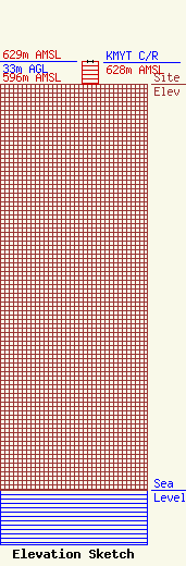
| Elevation Info |
Site Elevation: 596 meters (1955 ft) |
| Height of Structure: 33 meters (108 feet) |
| Overall Height Above Ground: 33 meters (108 feet) |
| Overall Height Above Mean Sea Level: 629 meters (2064 feet) |
| KMYT C/R Height Above Mean Sea Level: 628 meters (2060 ft)
|
| Owner Info | iHeartMedia Entertainment, Inc.
7136 S. Yale Avenue
TULSA, OK 74136
(918) 664-4581
fcccontact@iheartmedia.com |
| Contact Info | iHeartMedia, Inc.
7136 S. Yale Avenue
TULSA, OK 74136
(918) 664-4581
fcccontact@iheartmedia.com |
