|
|
Antenna Structure Registration 1016353 |
 |
Registration Info | Registration Number: 1016353 |
| File Number: A0906882 |
| FAA Study: 87-AGL-735-OE |
| FAA Issue Date: 08/26/1987 |
| Status: Constructed |
| Date Constructed: 09/01/1988 |
| FAA EMI: N |
| NEPA: N |
Structure Info
| Structure Type: MTOWER |
| Structure Coordinates: 42-33-15.0 N 82-53-15.0 W (NAD 83) |
| Structure Coordinates: 42-33-14.9 N 82-53-15.3 W (Converted to NAD 27) |
| Structure Address: 22590 15 Mile Rd 2.6 Km S |
| Structure City: Mount Clemens, MI |
| Structure County: Macomb County |
| Painting & Lighting Info |
FAA Circular #: 70/7460-1 |
FCC Paragraph(s): 1, 3, 5, 14, 21 |
Remarks: RED LIGHTS/PAINT |
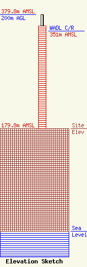
| Elevation Info |
Site Elevation: 179.8 meters (590 ft) |
| Height of Structure: 180 meters (591 feet) |
| Overall Height Above Ground: 200 meters (656 feet) |
| Overall Height Above Mean Sea Level: 379.8 meters (1246 feet) |
| WADL C/R Height Above Mean Sea Level: 351 meters (1152 ft)
|
| Owner Info | ADELL BROADCASTING CORPORATION
35000 ADELL DR
CLINTON TOWNSHIP, MI 48035-2814
(586) 790-3838
mikem@wadldetroit.com |
| Contact Info | ADELL BROADCASTING CORPORATION
35000 ADELL DR
CLINTON TOWNSHIP, MI 48035-2814
(586) 790-3838
mikem@wadldetroit.com |
