|
|
Antenna Structure Registration 1018700 |
 |
Registration Info | Registration Number: 1018700 |
| File Number: A1316030 |
| FAA Study: 92-AWP-0561-OE |
| FAA Issue Date: 07/17/1992 |
| Status: Constructed |
| Date Constructed: 01/01/1992 |
| NEPA: N |
Structure Info
| Structure Type: TOWER |
| Structure Coordinates: 34-27-47.0 N 116-52-47.0 W (NAD 83) |
| Structure Coordinates: 34-27-47.0 N 116-52-43.9 W (Converted to NAD 27) |
| Structure Address: 5.5 Mi W |
| Structure City: Lucerne Valley, CA |
| Structure County: San Bernardino County |
| Painting & Lighting Info |
FAA Chapters: NONE |
| Elevation Info |
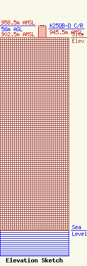
Site Elevation: 902.5 meters (2961 ft) |
| Height of Structure: 56 meters (184 feet) |
| Overall Height Above Ground: 56 meters (184 feet) |
| Overall Height Above Mean Sea Level: 958.5 meters (3145 feet) |
| K25QB-D C/R Height Above Mean Sea Level: 945.5 meters (3102 ft)
|
| Owner Info | SAN BERNARDINO COUNTY
222 WEST HOSPITALITY LANE
SAN BERNARDINO, CA 92415-0450
(909) 386-8800
FRANK.HAGGARD@SDD.SBCOUNTY.GOV |
| Contact Info | SAN BERNARDINO COUNTY
222 WEST HOSPITALITY LANE
SAN BERNARDINO, CA 92415-0450
FRANK HAGGARD
(909) 386-8800
FRANK.HAGGARD@SDD.SBCOUNTY.GOV |
