|
|
Antenna Structure Registration 1018701 |
 |
Registration Info | Registration Number: 1018701 |
| File Number: A1316032 |
| FAA Study: 92-AWP-0560-OE |
| FAA Issue Date: 07/17/1992 |
| Status: Constructed |
| Date Constructed: 01/01/1992 |
| NEPA: N |
Structure Info
| Structure Type: TOWER |
| Structure Coordinates: 34-53-7.0 N 116-53-48.0 W (NAD 83) |
| Structure Coordinates: 34-53-07.1 N 116-53-44.9 W (Converted to NAD 27) |
| Structure Address: 1.7 Mi Sse |
| Structure City: Daggett, CA |
| Structure County: San Bernardino County |
| Painting & Lighting Info |
FAA Circular #: 70/7460-1H |
FAA Chapters: 3, 4, 5, 13 |
| Elevation Info |
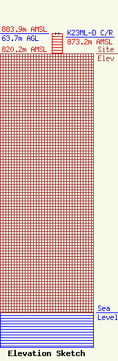
Site Elevation: 820.2 meters (2691 ft) |
| Height of Structure: 63.7 meters (209 feet) |
| Overall Height Above Ground: 63.7 meters (209 feet) |
| Overall Height Above Mean Sea Level: 883.9 meters (2900 feet) |
| K23ML-D C/R Height Above Mean Sea Level: 873.2 meters (2865 ft)
|
| Owner Info | SAN BERNARDINO COUNTY
222 WEST HOSPITALITY LANE
SAN BERNARDINO, CA 92415-0450
(909) 386-8800
FRANK.HAGGARD@SDD.SBCOUNTY.GOV |
| Contact Info | SAN BERNARDINO COUNTY
222 WEST HOSPITALITY LANE
SAN BERNARDINO, CA 92415-0450
FRANK HAGGARD
(909) 386-8800
FRANK.HAGGARD@SDD.SBCOUNTY.GOV |
