|
|
Antenna Structure Registration 1019112 |
 |
Registration Info | Registration Number: 1019112 |
| File Number: A0839329 |
| FAA Study: 2013-ASW-2317-OE |
| FAA Issue Date: 05/14/2013 |
| Status: Granted |
| Date Constructed: 04/22/1988 |
| NEPA: N |
Structure Info
| Structure Type: GTOWER |
| Structure Coordinates: 34-12-10.0 N 97-9-13.0 W (NAD 83) |
| Structure Coordinates: 34-12-09.7 N 97-09-11.9 W (Converted to NAD 27) |
| Structure Address: .6 Mi E Int I-35 & St Hwy 142 |
| Structure City: Ardmore, OK |
| Structure County: Carter County |
| Painting & Lighting Info |
FAA Circular #: 70/7460-1K |
FAA Chapters: 4, 8, 12 |
Remarks: PRIOR STUDIES 1987-ASW-1950-OE / 2007-ASW-11415-OE |
Remarks: OM&L to remain the same as prior studies = A MED-DUAL SYSTEM |
Remarks: PRIOR STUDIES 1987-ASW-1950-OE / 2007-ASW-11415-OE |
Remarks: OM&L to remain the same as prior studies = A MED-DUAL SYSTEM |
| Elevation Info |
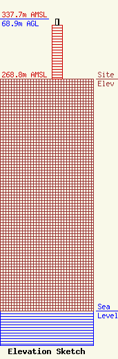
Site Elevation: 268.8 meters (882 ft) |
| Height of Structure: 62.4 meters (205 feet) |
| Overall Height Above Ground: 68.9 meters (226 feet) |
| Overall Height Above Mean Sea Level: 337.7 meters (1108 feet) |
| K36KE-D C/R Height Above Mean Sea Level: 0 meters (0 ft)
|
| Owner Info | Oklahoma State Regents for Higher Ed
108850
Oklahoma City, OK 73101
(405) 225-9453
rcrosby@onenet.net |
| Contact Info | Oklahoma State Regents for Higher Education
108850
Oklahoma City, OK 73101
(405) 225-9453
rcrosby@onenet.net |
