|
|
Antenna Structure Registration 1020781 |
 |
Registration Info | Registration Number: 1020781 |
| File Number: A1155210 |
| FAA Study: 2011-ASO-6384-OE |
| FAA Issue Date: 11/01/2011 |
| Status: Constructed |
| Date Constructed: 07/01/2008 |
| NEPA: N |
Structure Info
| Structure Type: GTOWER |
| Structure Coordinates: 28-55-11.1 N 81-19-6.6 W (NAD 83) |
| Structure Coordinates: 28-55-10.1 N 81-19-07.4 W (Converted to NAD 27) |
| Structure Address: 520 Miller Rd (302759) |
| Structure City: Orange City, FL |
| Structure County: Volusia County |
| Painting & Lighting Info |
FAA Circular #: 70/7460-1K |
FAA Chapters: 4, 7, 12 |
Remarks: PRIOR STUDY 2010-ASO-5243-OE |
| Elevation Info |
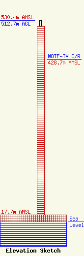
Site Elevation: 17.7 meters (58 ft) |
| Height of Structure: 497.4 meters (1632 feet) |
| Overall Height Above Ground: 512.7 meters (1682 feet) |
| Overall Height Above Mean Sea Level: 530.4 meters (1740 feet) |
| WOTF-TV C/R Height Above Mean Sea Level: 428.7 meters (1406 ft)
|
| Owner Info | American Towers, LLC
10 Presidential Way
Woburn, MA 01801
(781) 926-4500
faa-fcc@americantower.com |
| Contact Info | American Towers, LLC
10 Presidential Way
Woburn, MA 01801
(781) 926-4500
faa-fcc@americantower.com |
