|
|
Antenna Structure Registration 1022700 |
 |
Registration Info | Registration Number: 1022700 |
| File Number: A1035275 |
| FAA Study: 2012-ASO-3342-OE |
| FAA Issue Date: 04/24/2012 |
| Status: Constructed |
| Date Constructed: 08/18/2003 |
| FAA EMI: N |
| NEPA: N |
Structure Info
|
| Structure Coordinates: 33-59-35.9 N 83-24-55.9 W (NAD 83) |
| Structure Coordinates: 33-59-35.5 N 83-24-56.3 W (Converted to NAD 27) |
| Structure Address: 178 Pepperidge Lane (026166) |
| Structure City: Athens, GA |
| Structure County: Clarke County |
| Painting & Lighting Info |
FAA Circular #: 70/7460-1K |
FAA Chapters: 4, 8, 12 |
Remarks: PRIOR STUDY 2007-ASO-532-OE |
| Elevation Info |
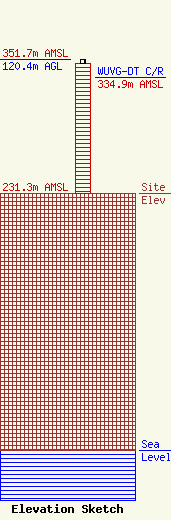
Site Elevation: 231.3 meters (759 ft) |
| Height of Structure: 116.7 meters (383 feet) |
| Overall Height Above Ground: 120.4 meters (395 feet) |
| Overall Height Above Mean Sea Level: 351.7 meters (1154 feet) |
| WUVG-DT C/R Height Above Mean Sea Level: 334.9 meters (1099 ft)
|
| Owner Info | American Towers LLC
10 Presidential Way
Woburn, MA 01801
(781) 926-4500
faa-fcc@americantower.com |
| Contact Info | American Towers, LLC
10 Presidential Way
Woburn, MA 01801
(781) 926-4500
faa-fcc@americantower.com |
