|
|
Antenna Structure Registration 1022981 |
 |
Registration Info | Registration Number: 1022981 |
| File Number: A0349420 |
| Status: Terminated |
| Date Constructed: 02/01/1986 |
| FAA EMI: N |
| NEPA: N |
Structure Info
| Structure Type: TOWER |
| Structure Coordinates: 38-44-43.0 N 104-51-44.0 W (NAD 83) |
| Structure Coordinates: 38-44-43.0 N 104-51-42.1 W (Converted to NAD 27) |
| Structure Address: 6180 Transmitter Lane |
| Structure City: Colorado Springs, CO |
| Structure County: El Paso County |
| Painting & Lighting Info |
FCC Paragraph(s): None |
| Elevation Info |
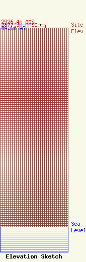
Site Elevation: 2877.3 meters (9440 ft) |
| Height of Structure: 45.7 meters (150 feet) |
| Overall Height Above Ground: 49.1 meters (161 feet) |
| Overall Height Above Mean Sea Level: 2926.4 meters (9601 feet) |
| K11XJ-D C/R Height Above Mean Sea Level: 2903.3 meters (9525 ft)
|
| Owner Info | Verizon Wireless (VAW) LLC
One Verizon Place (MC: GA3B1REG)
Alpharetta, GA 30004-8511
(678) 339-4271
Pamelia.Hoof@VerizonWireless.com |
| Contact Info | Verizon Wireless
One Verizon Place (MC: GA3B1REG)
Alpharetta, GA 30004-8511
Pamelia Hoof
(678) 339-4271
Pamelia.Hoof@VerizonWireless.com |
