|
|
Antenna Structure Registration 1023384 |
 |
Registration Info | Registration Number: 1023384 |
| File Number: A0816339 |
| FAA Study: 2006-AGL-3918-OE |
| FAA Issue Date: 09/27/2006 |
| Status: Constructed |
| Date Constructed: 07/15/1999 |
| FAA EMI: N |
| NEPA: N |
Structure Info
| Structure Type: TOWER |
| Structure Coordinates: 45-55-55.4 N 95-26-43.8 W (NAD 83) |
| Structure Coordinates: 45-55-55.5 N 95-26-42.7 W (Converted to NAD 27) |
| Structure Address: West Of: 4300 Cr-22 (alexandria # 50016) |
| Structure City: Garfield, MN |
| Structure County: Douglas County |
| Painting & Lighting Info |
FAA Circular #: 70/7460-1J |
FAA Chapters: 4, 8, 13 |
Remarks: PRIOR STUDY 2004-AGL-6359-OE |
Remarks: OM&L to remain the same as prior study = A MED-DUAL SYSTEM |
Remarks: PRIOR STUDY 2004-AGL-6359-OE |
Remarks: OM&L to remain the same as prior study = A MED-DUAL SYSTEM |
| Elevation Info |
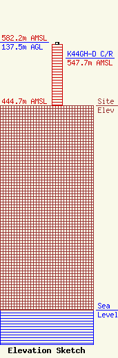
Site Elevation: 444.7 meters (1459 ft) |
| Height of Structure: 132.9 meters (436 feet) |
| Overall Height Above Ground: 137.5 meters (451 feet) |
| Overall Height Above Mean Sea Level: 582.2 meters (1910 feet) |
| K44GH-D C/R Height Above Mean Sea Level: 547.7 meters (1797 ft)
|
| Owner Info | American Towers LLC
10 Presidential Way
Woburn, MA 01801
(678) 564-3236
faa-fcc@americantower.com |
| Contact Info | American Towers, LLC.
10 Presidential Way
Woburn, MA 01801
(678) 564-3236
faa-fcc@americantower.com |
