|
|
Antenna Structure Registration 1024171 |
 |
Registration Info | Registration Number: 1024171 |
| File Number: A0028854 |
| FAA Study: 78-RM-547-OE |
| FAA Issue Date: 01/05/1979 |
| Status: Constructed |
| Date Constructed: 07/25/1979 |
| NEPA: N |
Structure Info
| Structure Type: TOWER |
| Structure Coordinates: 40-30-37.0 N 102-21-35.0 W (NAD 83) |
| Structure Coordinates: 40-30-37.0 N 102-21-33.3 W (Converted to NAD 27) |
| Structure Address: 8.8 Km Sw |
| Structure City: Holyoke, CO |
| Structure County: Phillips County |
| Painting & Lighting Info |
FCC Paragraph(s): 1, 3, 11, 21 |
Remarks: RED LIGHTS/PAINT |
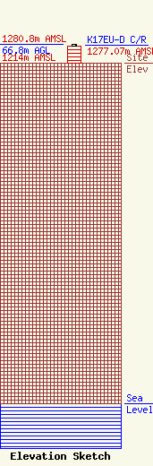
| Elevation Info |
Site Elevation: 1214 meters (3983 ft) |
| Height of Structure: 61 meters (200 feet) |
| Overall Height Above Ground: 66.8 meters (219 feet) |
| Overall Height Above Mean Sea Level: 1280.8 meters (4202 feet) |
| K17EU-D C/R Height Above Mean Sea Level: 1277.07 meters (4190 ft)
|
| Owner Info | TRI-STATE GENERATION & TRANSMISSION ASSOCIATION INC
1100 W 116TH AVE
33695
DENVER, CO 80233-0695
(303) 452-6111
DARBRU@TRISTATEGT.ORG |
