|
|
Antenna Structure Registration 1024622 |
 |
Registration Info | Registration Number: 1024622 |
| File Number: A0859165 |
| FAA Study: 98-ANM-1078-OE |
| FAA Issue Date: 11/30/1998 |
| Status: Constructed |
| Date Constructed: 01/01/1978 |
| FAA EMI: N |
| NEPA: N |
Structure Info
| Structure Type: TOWER |
| Structure Coordinates: 39-43-50.0 N 102-28-58.0 W (NAD 83) |
| Structure Coordinates: 39-43-50.0 N 102-28-56.3 W (Converted to NAD 27) |
| Structure Address: 10.5 Mi Wnw |
| Structure City: Idalia, CO |
| Structure County: Yuma County |
| Painting & Lighting Info |
FAA Circular #: 70/7460-1J |
FAA Chapters: 4, 8, 13 |
Remarks: PREV. 78-RM-452-OE. |
| Elevation Info |
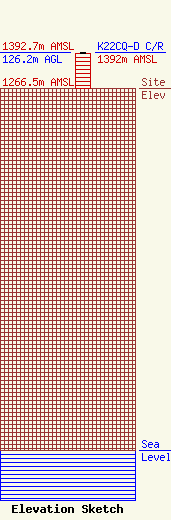
Site Elevation: 1266.5 meters (4155 ft) |
| Height of Structure: 121.9 meters (400 feet) |
| Overall Height Above Ground: 126.2 meters (414 feet) |
| Overall Height Above Mean Sea Level: 1392.7 meters (4569 feet) |
| K22CQ-D C/R Height Above Mean Sea Level: 1392 meters (4567 ft)
|
| Owner Info | REGION 1 TRANSLATORS ASSOCIATION
323 West 4th Ave
Yuma, CO 80759
(970) 630-3854
rfsystemsllc@gmail.com |
| Contact Info | RF Systems LLC
323 West 4th Ave
Yuma, CO 80759
Ed Lake
(970) 630-3854
rfsystemsllc@gmail.com |
