|
|
Antenna Structure Registration 1025369 |
 |
Registration Info | Registration Number: 1025369 |
| File Number: A1291941 |
| FAA Study: 2014-ANM-1358-OE |
| FAA Issue Date: 05/23/2014 |
| Status: Constructed |
| Date Constructed: 02/03/2012 |
| FAA EMI: N |
| NEPA: N |
Structure Info
| Structure Type: GTOWER |
| Structure Coordinates: 38-21-28.9 N 104-38-10.5 W (NAD 83) |
| Structure Coordinates: 38-21-28.9 N 104-38-08.6 W (Converted to NAD 27) |
| Structure Address: Twr 3 - 1 Mi W Of I-25 4.8 Mi N |
| Structure City: Pueblo, CO |
| Structure County: Pueblo County |
| Painting & Lighting Info |
FAA Circular #: 70/7460-1F |
FAA Chapters: 3, 4, 5, 9 |
Remarks: PRIOR STUDY 2012-ANM-61-OE |
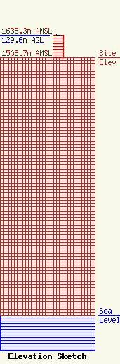
| Elevation Info |
Site Elevation: 1508.7 meters (4950 ft) |
| Height of Structure: 129 meters (423 feet) |
| Overall Height Above Ground: 129.6 meters (425 feet) |
| Overall Height Above Mean Sea Level: 1638.3 meters (5375 feet) |
| Owner Info | VB-S1 Assets, LLC
750 Park Commerce Drive Suite 200
Boca Raton, FL 33487
(561) 406-4023
Fcc-faa@verticalbridge.com |
| Contact Info | VB-S1 Assets, LLC
750 Park Commerce Drive Suite 200
Boca Raton, FL 33487
Matt Bonfante
(561) 406-4023
Fcc-faa@verticalbridge.com |
