|
|
Antenna Structure Registration 1025601 |
 |
Registration Info | Registration Number: 1025601 |
| File Number: A0897485 |
| FAA Study: 2003-ANM-1635-OE |
| FAA Issue Date: 08/15/2003 |
| Status: Constructed |
| Date Constructed: 01/12/2004 |
| FAA EMI: N |
| NEPA: N |
Structure Info
| Structure Type: TOWER |
| Structure Coordinates: 39-51-16.9 N 103-20-39.7 W (NAD 83) |
| Structure Coordinates: 39-51-17.0 N 103-20-37.9 W (Converted to NAD 27) |
| Structure Address: 8 Mi N 3 Mi E |
| Structure City: Lindon, CO |
| Structure County: Washington County |
| Painting & Lighting Info |
FAA Circular #: 70/7460-1K |
FAA Chapters: 4, 6, 12 |
Remarks: Removed expiration date from determination. Scenario 1./jjs/case#635066 |
Remarks: PRIOR STUDY 1995-ANM-955-OE |
Remarks: Removed expiration date from determination. Scenario 1./jjs/case#635066 |
Remarks: PRIOR STUDY 1995-ANM-955-OE |
| Elevation Info |
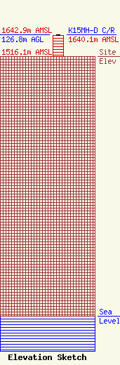
Site Elevation: 1516.1 meters (4974 ft) |
| Height of Structure: 121.9 meters (400 feet) |
| Overall Height Above Ground: 126.8 meters (416 feet) |
| Overall Height Above Mean Sea Level: 1642.9 meters (5390 feet) |
| K15MH-D C/R Height Above Mean Sea Level: 1640.1 meters (5381 ft)
|
| Owner Info | BOARD OF WASHINGTON COUNTY COMMISSIONERS
WASHINGTON CTY COURTHOUSE
AKRON, CO 80720-1510
(970) 630-3854
rfsystemsllc@gmail.com |
| Contact Info | RF Systems LLC
323 W 4th Ave
Yuma, CO 80759
Ed Lake
(970) 630-3854
rfsystemsllc@gmail.com |
