|
|
Antenna Structure Registration 1026131 |
 |
Registration Info | Registration Number: 1026131 |
| File Number: A0246917 |
| FAA Study: 93-AEA-1277-OE |
| FAA Issue Date: 01/25/1994 |
| Status: Constructed |
| Date Constructed: 10/26/1996 |
| FAA EMI: N |
| NEPA: N |
Structure Info
| Structure Type: TOWER |
| Structure Coordinates: 40-29-43.0 N 80-0-16.0 W (NAD 83) |
| Structure Coordinates: 40-29-42.8 N 80-00-16.8 W (Converted to NAD 27) |
| Structure Address: 750 Ivory Ave |
| Structure City: Pittsburgh, PA |
| Structure County: Allegheny County |
| Painting & Lighting Info |
FAA Circular #: 70/7460-1H |
FAA Chapters: 3, 4, 5, 13 |
| Elevation Info |
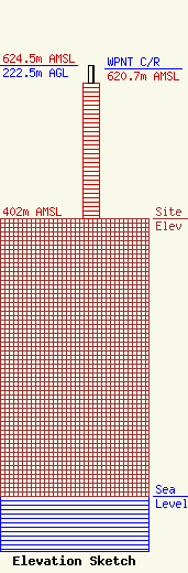
Site Elevation: 402 meters (1319 ft) |
| Height of Structure: 196.6 meters (645 feet) |
| Overall Height Above Ground: 222.5 meters (730 feet) |
| Overall Height Above Mean Sea Level: 624.5 meters (2049 feet) |
| WPNT C/R Height Above Mean Sea Level: 620.7 meters (2036 ft)
|
| Owner Info | Gerstell Development Limited Partnership
10706 Beaver Dam Road
Cockeysville, MD 21030
(410) 568-1500
|
