|
|
Antenna Structure Registration 1027474 |
 |
Registration Info | Registration Number: 1027474 |
| File Number: A1226399 |
| FAA Study: 2021-AEA-16703-OE |
| FAA Issue Date: 10/19/2022 |
| Status: Constructed |
| Date Constructed: 06/27/2010 |
| NEPA: N |
Structure Info
| Structure Type: GTOWER |
| Structure Coordinates: 36-48-32.5 N 76-30-11.3 W (NAD 83) |
| Structure Coordinates: 36-48-32.0 N 76-30-12.5 W (Converted to NAD 27) |
| Structure Address: 3702b Nansemond Pky (010192) |
| Structure City: Suffolk, VA |
| Structure County: Suffolk city |
| Painting & Lighting Info |
FAA Chapters: NONE |
Remarks: PRIOR STUDY 2010-AEA-2732-OE |
| Elevation Info |
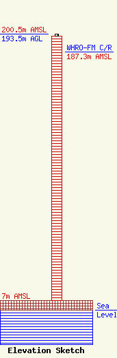
Site Elevation: 7 meters (23 ft) |
| Height of Structure: 192 meters (630 feet) |
| Overall Height Above Ground: 193.5 meters (635 feet) |
| Overall Height Above Mean Sea Level: 200.5 meters (658 feet) |
| WHRO-FM C/R Height Above Mean Sea Level: 187.3 meters (615 ft)
|
| Owner Info | American Towers LLC
10 Presidential Way
Woburn, MA 01801
(781) 926-4500
faa-fcc@americantower.com |
| Contact Info | American Towers LLC
10 Presidential Way
Woburn, MA 01801
(781) 926-4500
faa-fcc@americantower.com |
