|
|
Antenna Structure Registration 1027622 |
 |
Registration Info | Registration Number: 1027622 |
| File Number: A0829963 |
| Status: Constructed |
| Date Constructed: 08/01/1957 |
| FAA EMI: N |
| NEPA: N |
Structure Info
| Structure Type: TOWER |
| Structure Coordinates: 41-5-38.0 N 85-10-48.0 W (NAD 83) |
| Structure Coordinates: 41-05-37.8 N 85-10-48.1 W (Converted to NAD 27) |
| Structure Address: 2915 W State Blvd |
| Structure City: Fort Wayne, IN |
| Structure County: Allen County |
| Painting & Lighting Info |
FCC Paragraph(s): 1, 3, 6, 15, 21 |
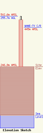
| Elevation Info |
Site Elevation: 246.9 meters (810 ft) |
| Height of Structure: 238 meters (781 feet) |
| Overall Height Above Ground: 255.7 meters (839 feet) |
| Overall Height Above Mean Sea Level: 502.6 meters (1649 feet) |
| WANE-TV C/R Height Above Mean Sea Level: 445 meters (1460 ft)
|
| Owner Info | LWWI BROADCASTING INC DBA = WANE TV
1515
FORT WAYNE, IN 46808
(260) 481-1590
jeff.kracium@wane.com |
| Info |
