|
|
Antenna Structure Registration 1027886 |
 |
Registration Info | Registration Number: 1027886 |
| File Number: A0867492 |
| Status: Constructed |
| Date Constructed: 04/01/1971 |
| FAA EMI: N |
| NEPA: N |
Structure Info
| Structure Type: TOWER |
| Structure Coordinates: 47-32-8.0 N 111-17-5.0 W (NAD 83) |
| Structure Coordinates: 47-32-08.2 N 111-17-02.1 W (Converted to NAD 27) |
| Structure Address: Us Hwy 87 1 Mi N Of Missouri River |
| Structure City: Great Falls, MT |
| Structure County: Cascade County |
| Painting & Lighting Info |
FCC Paragraph(s): 1, 3, 4, 13, 21 |
| Elevation Info |
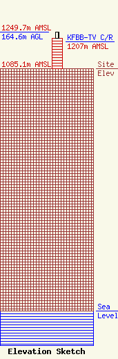
Site Elevation: 1085.1 meters (3560 ft) |
| Height of Structure: 138.1 meters (453 feet) |
| Overall Height Above Ground: 164.6 meters (540 feet) |
| Overall Height Above Mean Sea Level: 1249.7 meters (4100 feet) |
| KFBB-TV C/R Height Above Mean Sea Level: 1207 meters (3960 ft)
|
| Owner Info | Cowles Montana Media Company
2200 Stephens Avenue
Missoula, MT 59801
(406) 542-8900
Linda.Gray@CowlesMontana.com |
| Contact Info | Skadden, Arps, Slate, Meagher & Flom LLP
1440 New York Avenue, NW
Washington, DC 20005
David Pawlik
(202) 237-1704
dpawlik@skadden.com |
