|
|
Antenna Structure Registration 1027973 |
 |
Registration Info | Registration Number: 1027973 |
| File Number: A1263574 |
| FAA Study: 2022-AGL-7372-OE |
| FAA Issue Date: 01/20/2023 |
| Status: Constructed |
| Date Constructed: 10/25/1974 |
| NEPA: N |
Structure Info
| Structure Type: LTOWER |
| Structure Coordinates: 44-59-44.0 N 93-26-56.5 W (NAD 83) |
| Structure Coordinates: 44-59-44.1 N 93-26-55.7 W (Converted to NAD 27) |
| Structure Address: 13320 15th Ave. N (#87853) |
| Structure City: Minneapolis, MN |
| Structure County: Hennepin County |
| Painting & Lighting Info |
FAA Circular #: 70/7460-1J |
FAA Chapters: 4, 6, 13 |
Remarks: PRIOR STUDY 2012-AGL-1652-OE |
Remarks: OM&L to remain the same as prior study = 24-HR MED-STROBES |
Remarks: PRIOR STUDY 2012-AGL-1652-OE |
Remarks: OM&L to remain the same as prior study = 24-HR MED-STROBES |
| Elevation Info |
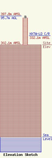
Site Elevation: 302.1 meters (991 ft) |
| Height of Structure: 88.7 meters (291 feet) |
| Overall Height Above Ground: 95.7 meters (314 feet) |
| Overall Height Above Mean Sea Level: 397.8 meters (1305 feet) |
| KKTW-LD C/R Height Above Mean Sea Level: 332.1 meters (1090 ft)
|
| Owner Info | American Towers LLC
10 Presidential Way
Woburn, MA 01801
(781) 926-4500
faa-fcc@americantower.com |
| Contact Info | American Towers LLC
10 Presidential Way
Woburn, MA 01801
(781) 926-4500
faa-fcc@americantower.com |
