|
|
Antenna Structure Registration 1029136 |
 |
Registration Info | Registration Number: 1029136 |
| File Number: A0034574 |
| FAA Study: 91-ASO-1872-OE |
| FAA Issue Date: 02/26/1992 |
| Status: Constructed |
| Date Constructed: 11/23/1993 |
| NEPA: N |
Structure Info
| Structure Type: TOWER |
| Structure Coordinates: 29-48-43.0 N 82-42-33.0 W (NAD 83) |
| Structure Coordinates: 29-48-42.1 N 82-42-33.6 W (Converted to NAD 27) |
| Structure Address: 5889 Ne County Rd Box 340 |
| Structure City: High Springs, FL |
| Structure County: Gilchrist County |
| Painting & Lighting Info |
FAA Circular #: 70/7460-1H |
FAA Chapters: 3, 4, 5, 13 |
| Elevation Info |
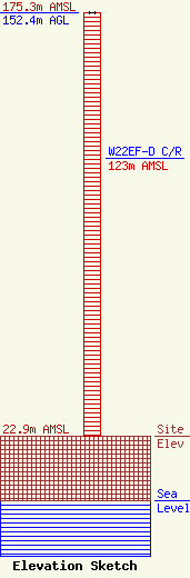
Site Elevation: 22.9 meters (75 ft) |
| Height of Structure: 152.4 meters (500 feet) |
| Overall Height Above Ground: 152.4 meters (500 feet) |
| Overall Height Above Mean Sea Level: 175.3 meters (575 feet) |
| W22EF-D C/R Height Above Mean Sea Level: 123 meters (404 ft)
|
| Owner Info | TOWER PROPERTIES OF FLORIDA INC
4190 NW 93RD AVE
GAINESVILLE, FL 32653
(352) 378-5522
GCOOP@IBM.NET |
