|
|
Antenna Structure Registration 1029990 |
 |
Registration Info | Registration Number: 1029990 |
| File Number: A0382963 |
| Status: Constructed |
| Date Constructed: 08/01/1991 |
| FAA EMI: N |
| NEPA: N |
Structure Info
| Structure Type: TOWER |
| Structure Coordinates: 40-39-14.0 N 122-31-17.0 W (NAD 83) |
| Structure Coordinates: 40-39-14.5 N 122-31-12.9 W (Converted to NAD 27) |
| Structure Address: 0.3 Km East Of South Mountain Lookout |
| Structure City: Redding, CA |
| Structure County: Shasta County |
| Painting & Lighting Info |
FCC Paragraph(s): None |
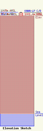
| Elevation Info |
Site Elevation: 968.4 meters (3177 ft) |
| Height of Structure: 30.5 meters (100 feet) |
| Overall Height Above Ground: 36.6 meters (120 feet) |
| Overall Height Above Mean Sea Level: 1005 meters (3297 feet) |
| KNNN-LP C/R Height Above Mean Sea Level: 1001.4 meters (3285 ft)
|
| Owner Info | TARS, INC.
990970
Redding, CA 96099-0970
(530) 241-6025
|
| Contact Info | Schwaninger & Associates, P.C.
1331 H Street, NW, Suite 500
Washington, DC 20005
Richard Hanno
(202) 347-8580
rhanno@sa-lawyers.net |
