|
|
Antenna Structure Registration 1030889 |
 |
Registration Info | Registration Number: 1030889 |
| File Number: A1313178 |
| FAA Study: 01-ASO-8217-OE |
| FAA Issue Date: 01/28/2002 |
| Status: Constructed |
| Date Constructed: 08/20/2002 |
| FAA EMI: N |
| NEPA: N |
Structure Info
| Structure Type: TOWER |
| Structure Coordinates: 30-35-16.7 N 87-33-12.7 W (NAD 83) |
| Structure Coordinates: 30-35-16.0 N 87-33-12.8 W (Converted to NAD 27) |
| Structure Address: Route 87, South Of I-10 |
| Structure City: Elsanor, AL |
| Structure County: Baldwin County |
| Painting & Lighting Info |
FAA Circular #: 70/7460-1J |
FAA Chapters: 4, 7, 13 |
Remarks: Removed expiration date from determination. Scenario 1./jjs/case#635066 |
Remarks: PRIOR STUDY 97-ASO-6223-OE |
Remarks: Removed expiration date from determination. Scenario 1./jjs/case#635066 |
Remarks: PRIOR STUDY 97-ASO-6223-OE |
| Elevation Info |
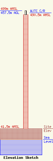
Site Elevation: 41.5 meters (136 ft) |
| Height of Structure: 441 meters (1447 feet) |
| Overall Height Above Ground: 457.5 meters (1501 feet) |
| Overall Height Above Mean Sea Level: 499 meters (1637 feet) |
| WJTC C/R Height Above Mean Sea Level: 490.5 meters (1609 ft)
|
| Owner Info | Deerfield Media (Mobile) Licensee, LLC
573 E 840 S
Heber City, UT 84032
(435) 315-3047
dturner@manhanmedia.com |
| Contact Info | Pillsbury Winthrop Shaw Pittman LLP
1200 Seventeenth Street, NW
Washington, DC 20036
Scott Flick
(202) 663-8167
scott.flick@pillsburylaw.com |
