|
|
Antenna Structure Registration 1031203 |
 |
Registration Info | Registration Number: 1031203 |
| File Number: A1300685 |
| FAA Study: 2024-ASO-9385-OE |
| FAA Issue Date: 05/30/2024 |
| Status: Constructed |
| Date Constructed: 08/20/2024 |
| NEPA: N |
Structure Info
| Structure Type: GTOWER |
| Structure Coordinates: 30-34-25.5 N 84-12-12.7 W (NAD 83) |
| Structure Coordinates: 30-34-24.8 N 84-12-13.1 W (Converted to NAD 27) |
| Structure Address: 7927 Thomasville Road |
| Structure City: Tallahassee, FL |
| Structure County: Leon County |
| Painting & Lighting Info |
FAA Circular #: 70/7460-1L |
FAA Chapters: 3, 4, 5, 12 |
Remarks: PRIOR STUDY 2024-ASO-5337-OE |
Remarks: OM&L to remain the same as prior study = PAINT/RED LIGHTS |
Remarks: PRIOR STUDY 2024-ASO-5337-OE |
Remarks: OM&L to remain the same as prior study = PAINT/RED LIGHTS |
| Elevation Info |
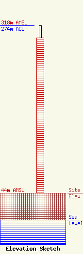
Site Elevation: 44 meters (144 ft) |
| Height of Structure: 254 meters (833 feet) |
| Overall Height Above Ground: 274 meters (899 feet) |
| Overall Height Above Mean Sea Level: 318 meters (1043 feet) |
| Owner Info | Gray Local Media, Inc.
4370 Peachtree Road, NE
Atlanta, GA 30319
(404) 266-8333
legalnotices@graymedia.com |
| Contact Info | Gray Local Media, Inc.
4370 Peachtree Road NE
Atlanta, GA 30319
Engineering Department
(404) 266-8333
legalnotices@graymedia.com |
