|
|
Antenna Structure Registration 1032456 |
 |
Registration Info | Registration Number: 1032456 |
| File Number: A1063851 |
| FAA Study: 97-ANM-1312-OE |
| Status: Constructed |
| Date Constructed: 01/01/1953 |
| FAA EMI: N |
| NEPA: N |
Structure Info
| Structure Type: TOWER |
| Structure Coordinates: 47-37-55.0 N 122-21-14.0 W (NAD 83) |
| Structure Coordinates: 47-37-55.6 N 122-21-09.5 W (Converted to NAD 27) |
| Structure Address: 157 Galer Street |
| Structure City: Seattle, WA |
| Structure County: King County |
| Painting & Lighting Info |
FAA Circular #: 70/7460-1J |
FAA Chapters: 3, 4, 8, 13 |
| Elevation Info |
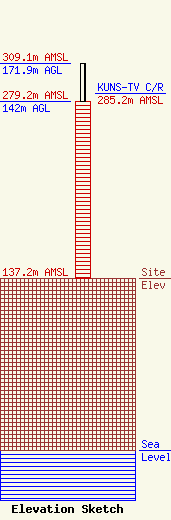
Site Elevation: 137.2 meters (450 ft) |
| Height of Structure: 142 meters (466 feet) |
| Overall Height Above Ground: 171.9 meters (564 feet) |
| Overall Height Above Mean Sea Level: 309.1 meters (1014 feet) |
| KUNS-TV C/R Height Above Mean Sea Level: 285.2 meters (936 ft)
|
| Owner Info | Sinclair Seattle Licensee, LLC
Pillsbury Winthrop Shaw Pittman LLP
Washington, DC 20036
(202) 663-8195
miles.mason@pillsburylaw.com |
| Contact Info | Sinclair Seattle Licensee, LLC
Pillsbury Winthrop Shaw Pittman LLP
Washington, DC 20036
(202) 663-8195
miles.mason@pillsburylaw.com |
