|
|
Antenna Structure Registration 1033740 |
 |
Registration Info | Registration Number: 1033740 |
| File Number: A1194740 |
| FAA Study: 2014-AEA-7355-OE |
| FAA Issue Date: 02/27/2015 |
| Status: Constructed |
| Date Constructed: 03/01/1996 |
| NEPA: N |
Structure Info
| Structure Type: LTOWER |
| Structure Coordinates: 40-18-57.8 N 76-57-1.0 W (NAD 83) |
| Structure Coordinates: 40-18-57.5 N 76-57-02.1 W (Converted to NAD 27) |
| Structure Address: Tower Road On Blue Mountain |
| Structure City: Summerdale, PA |
| Structure County: Cumberland County |
| Painting & Lighting Info |
FAA Circular #: 70/7460-1J |
FAA Chapters: 3, 4, 5, 13 |
Remarks: PRIOR STUDY 1997-AEA-1689-OE |
Remarks: OM&L to remain the same as prior study = PAINT/RED LIGHTS |
Remarks: PRIOR STUDY 1997-AEA-1689-OE |
Remarks: OM&L to remain the same as prior study = PAINT/RED LIGHTS |
| Elevation Info |
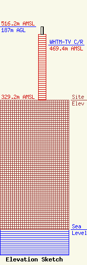
Site Elevation: 329.2 meters (1080 ft) |
| Height of Structure: 167.7 meters (550 feet) |
| Overall Height Above Ground: 187 meters (614 feet) |
| Overall Height Above Mean Sea Level: 516.2 meters (1694 feet) |
| WHTM-TV C/R Height Above Mean Sea Level: 469.4 meters (1540 ft)
|
| Owner Info | Nexstar Media Inc.
545 E. John Carpenter Freeway
Irving, TX 75062
(972) 373-8800
jasroberts@nexstar.tv |
| Contact Info | Nexstar Media Inc.
545 E. John Carpenter Freeway
Irving, TX 75062
Jason Roberts
(972) 373-8800
jasroberts@nexstar.tv |
