|
|
Antenna Structure Registration 1033792 |
 |
Registration Info | Registration Number: 1033792 |
| File Number: A1087107 |
| FAA Study: 2017-ANE-336-OE |
| FAA Issue Date: 02/15/2017 |
| Status: Constructed |
| Date Constructed: 01/01/1996 |
| NEPA: N |
Structure Info
| Structure Type: LTOWER |
| Structure Coordinates: 43-11-4.0 N 71-19-10.0 W (NAD 83) |
| Structure Coordinates: 43-11-03.7 N 71-19-11.8 W (Converted to NAD 27) |
| Structure Address: 544 Mountain View Road, Fort Mountain |
| Structure City: Epsom, NH |
| Structure County: Merrimack County |
| Painting & Lighting Info |
FAA Circular #: 70/7460-1L |
FAA Chapters: 3, 4, 5, 12 |
Remarks: PRIOR STUDY 2005-ANE-1098-OE |
| Elevation Info |
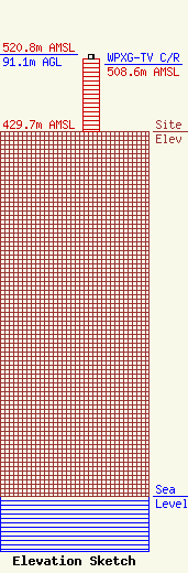
Site Elevation: 429.7 meters (1410 ft) |
| Height of Structure: 85.3 meters (280 feet) |
| Overall Height Above Ground: 91.1 meters (299 feet) |
| Overall Height Above Mean Sea Level: 520.8 meters (1709 feet) |
| WPXG-TV C/R Height Above Mean Sea Level: 508.6 meters (1669 ft)
|
| Owner Info | Industrial Tower and Wireless, LLC
40 Lone Street
Marshfield, MA 02050
(781) 319-1111
Kevin.Delaney@Induscom.com |
| Contact Info | Industrial Tower and Wireless, LLC
40 Lone Street
Marshfield, MA 02050
Kevin Delaney
(781) 319-1011
Kevin.Delaney@Induscom.com |
