|
|
Antenna Structure Registration 1035174 |
 |
Registration Info | Registration Number: 1035174 |
| File Number: A1064027 |
| FAA Study: 80-ASO-2123-OE |
| FAA Issue Date: 02/16/1982 |
| Status: Constructed |
| Date Constructed: 04/01/1986 |
| NEPA: N |
Structure Info
| Structure Type: TOWER |
| Structure Coordinates: 33-29-4.0 N 86-48-25.0 W (NAD 83) |
| Structure Coordinates: 33-29-03.6 N 86-48-25.0 W (Converted to NAD 27) |
| Structure Address: 2021 Golden Crest Drive |
| Structure City: Birmingham, AL |
| Structure County: Jefferson County |
| Painting & Lighting Info |
FCC Paragraph(s): A1, B, E, H, 3, 8, 17, 21, 23 |
Remarks: DUAL HIGH INTENSITY |
| Elevation Info |
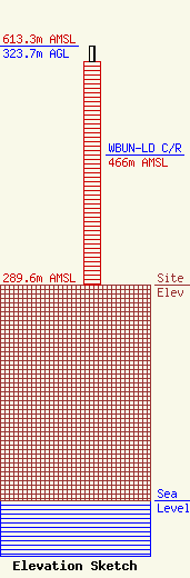
Site Elevation: 289.6 meters (950 ft) |
| Height of Structure: 301.8 meters (990 feet) |
| Overall Height Above Ground: 323.7 meters (1062 feet) |
| Overall Height Above Mean Sea Level: 613.3 meters (2012 feet) |
| WBUN-LD C/R Height Above Mean Sea Level: 466 meters (1529 ft)
|
| Owner Info | WTTO Licensee, LLC
Pillsbury Winthrop Shaw Pittman LLP
Washington, DC 20036
(202) 663-8195
miles.mason@pillsburylaw.com |
| Contact Info | WTTO Licensee, LLC
Pillsbury Winthrop Shaw Pittman LLP
Washington, DC 20036
(202) 663-8195
miles.mason@pillsburylaw.com |
