|
|
Antenna Structure Registration 1035286 |
 |
Registration Info | Registration Number: 1035286 |
| File Number: A0041705 |
| FAA Study: 97-ANE-0511-OE |
| FAA Issue Date: 10/16/1997 |
| Status: Constructed |
| Date Constructed: 01/01/1967 |
| NEPA: N |
Structure Info
| Structure Type: TOWER |
| Structure Coordinates: 41-31-14.0 N 72-10-1.0 W (NAD 83) |
| Structure Coordinates: 41-31-13.6 N 72-10-02.7 W (Converted to NAD 27) |
| Structure Address: Bishop Road, 3.2 Miles South Of Fitchville, Ct |
| Structure City: Bozrah, CT |
| Structure County: New London County |
| Painting & Lighting Info |
FCC Paragraph(s): 1, 3, 4, 13, 21 |
Remarks: Removed expiration date from determination. Scenario 1./jjs/case#635066 |
Remarks: RED LIGHTS/PAINT. |
| Elevation Info |
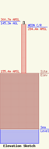
Site Elevation: 155.4 meters (510 ft) |
| Height of Structure: 137.1 meters (450 feet) |
| Overall Height Above Ground: 145.3 meters (477 feet) |
| Overall Height Above Mean Sea Level: 300.7 meters (987 feet) |
| WEDN C/R Height Above Mean Sea Level: 284.4 meters (933 ft)
|
| Owner Info | CONNECTICUT PUBLIC BROADCASTING, INC.
240 NEW BRITAIN AVENUE
HARTFORD, CT 06106
(860) 388-5487
|
