|
|
Antenna Structure Registration 1035355 |
 |
Registration Info | Registration Number: 1035355 |
| File Number: A1139015 |
| FAA Study: 97-ANE-0363-OE |
| FAA Issue Date: 10/16/1997 |
| Status: Constructed |
| Date Constructed: 01/01/1963 |
| FAA EMI: N |
| NEPA: N |
Structure Info
|
| Structure Coordinates: 44-45-45.0 N 68-33-56.0 W (NAD 83) |
| Structure Coordinates: 44-45-44.7 N 68-33-57.9 W (Converted to NAD 27) |
| Structure Address: Blackcap Mountain Off Route #46 |
| Structure City: East Eddington, ME |
| Structure County: Penobscot County |
| Painting & Lighting Info |
FCC Paragraph(s): 1, 3, 12, 21 |
Remarks: Removed expiration date from determination. Scenario 1./jjs/case#635066 |
Remarks: RED LIGHTS/PAINT. |
Remarks: Removed expiration date from determination. Scenario 1./jjs/case#635066 |
| Elevation Info |
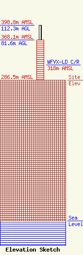
Site Elevation: 286.5 meters (940 ft) |
| Height of Structure: 81.6 meters (268 feet) |
| Overall Height Above Ground: 112.3 meters (368 feet) |
| Overall Height Above Mean Sea Level: 398.8 meters (1308 feet) |
| WFVX-LD C/R Height Above Mean Sea Level: 318 meters (1043 ft)
|
| Owner Info | Maine Public Broadcasting Corp
1450 Lisbon St.
Lewiston, ME 04240
(207) 404-5118
jmahaney@mainepublic.org |
| Contact Info | Maine Public Broadcasting Corp
63 Texas Ave
Bangor, ME 04401
Jeffrey Mahaney
(207) 404-5118
jmahaney@mainepublic.org |
