|
|
Antenna Structure Registration 1035474 |
 |
Registration Info | Registration Number: 1035474 |
| File Number: A0154383 |
| FAA Study: 97-AEA-0957-OE |
| FAA Issue Date: 07/20/1998 |
| Status: Constructed |
| Date Constructed: 10/23/1998 |
| FAA EMI: N |
| NEPA: N |
Structure Info
| Structure Type: TOWER |
| Structure Coordinates: 40-2-33.0 N 75-14-32.0 W (NAD 83) |
| Structure Coordinates: 40-02-32.6 N 75-14-33.4 W (Converted to NAD 27) |
| Structure Address: Foot Of Culp St. Near Domino Lane |
| Structure City: Philadelphia, PA |
| Structure County: Philadelphia County |
| Painting & Lighting Info |
FAA Circular #: 70/7460-1J |
FAA Chapters: 3, 4, 5, 13 |
Remarks: Removed expiration date from determination. Scenario 1./jjs/case#635066 |
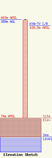
| Elevation Info |
Site Elevation: 74 meters (243 ft) |
| Height of Structure: 388 meters (1273 feet) |
| Overall Height Above Ground: 389 meters (1276 feet) |
| Overall Height Above Mean Sea Level: 463 meters (1519 feet) |
| KYW-TV C/R Height Above Mean Sea Level: 438.5 meters (1439 ft)
|
| Owner Info | ABC, INC. DBA = WPVI-TV
77 West 66th Street, 16th Floor
New York, NY 10023-6298
(212) 456-6222
|
