|
|
Antenna Structure Registration 1038731 |
 |
Registration Info | Registration Number: 1038731 |
| File Number: A0546392 |
| FAA Study: 97-AGL-4415-OE |
| FAA Issue Date: 10/14/1997 |
| Status: Constructed |
| Date Constructed: 08/03/1998 |
| FAA EMI: N |
| NEPA: N |
Structure Info
| Structure Type: TOWER |
| Structure Coordinates: 47-16-45.0 N 97-20-27.0 W (NAD 83) |
| Structure Coordinates: 47-16-45.1 N 97-20-25.7 W (Converted to NAD 27) |
| Structure Address: 3.5 Mi Ne |
| Structure City: Galesburg, ND |
| Structure County: Traill County |
| Painting & Lighting Info |
FAA Circular #: 70/7460-1J |
FAA Chapters: 4, 7, 13 |
| Elevation Info |
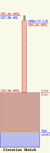
Site Elevation: 324.6 meters (1065 ft) |
| Height of Structure: 589.1 meters (1933 feet) |
| Overall Height Above Ground: 627.8 meters (2060 feet) |
| Overall Height Above Mean Sea Level: 952.4 meters (3125 feet) |
| KRDK-TV C/R Height Above Mean Sea Level: 890.6 meters (2922 ft)
|
| Owner Info | Parker Broadcasting of Dakota, LLC
5341 Tate Avenue
Plano, TX 75093
(701) 282-0444
|
| Contact Info | KXJB
1350 21st Avenue South
Fargo, ND 58103
Ronny Barr
(701) 237-5211
ronb@kx4.com |
