|
|
Antenna Structure Registration 1041052 |
 |
Registration Info | Registration Number: 1041052 |
| File Number: A0691341 |
| FAA Study: 2003-ASO-2618-OE |
| FAA Issue Date: 06/27/2003 |
| Status: Constructed |
| Date Constructed: 07/21/2010 |
| FAA EMI: N |
| NEPA: N |
Structure Info
| Structure Type: TOWER |
| Structure Coordinates: 30-45-19.0 N 88-56-44.0 W (NAD 83) |
| Structure Coordinates: 30-45-18.3 N 88-56-43.9 W (Converted to NAD 27) |
| Structure Address: N Side Tower Road, 1.1 Km E Of Cable Bridge Road |
| Structure City: Biloxi, MS |
| Structure County: Stone County |
| Painting & Lighting Info |
FAA Circular #: 70/7460-1K |
FAA Chapters: 4, 7, 12 |
Remarks: PRIOR STUDY 1997-ASO-6089-OE |
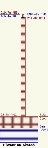
| Elevation Info |
Site Elevation: 53.3 meters (175 ft) |
| Height of Structure: 451.9 meters (1483 feet) |
| Overall Height Above Ground: 466.4 meters (1530 feet) |
| Overall Height Above Mean Sea Level: 519.7 meters (1705 feet) |
| WMAH-TV C/R Height Above Mean Sea Level: 511.8 meters (1679 ft)
|
| Owner Info | Mississippi Authority for Educational Television
3825 Ridgewood Road
Jackson, MS 39211
(601) 432-6381
Cy.Vance@mpbonline.org |
| Contact Info | Kessler and Gehman Associates, Inc.
507 NW 60th Street, Suite C
Gainesville, FL 32607-2055
William Godfrey
(352) 332-3157
billg@kga.bz |
