|
|
Antenna Structure Registration 1041402 |
 |
Registration Info | Registration Number: 1041402 |
| File Number: A0985007 |
| FAA Study: 97-ASO-1831-OE |
| FAA Issue Date: 02/19/2002 |
| Status: Constructed |
| Date Constructed: 10/17/2002 |
| FAA EMI: Y |
| NEPA: N |
Structure Info
| Structure Type: TOWER |
| Structure Coordinates: 25-58-47.0 N 80-11-45.0 W (NAD 83) |
| Structure Coordinates: 25-58-45.7 N 80-11-45.8 W (Converted to NAD 27) |
| Structure Address: 3300 Sw 52nd Ave |
| Structure City: Pembroke Park, FL |
| Structure County: Broward County |
| Painting & Lighting Info |
FAA Circular #: 70/7460-1K |
FAA Chapters: 4, 9, 12 |
| Elevation Info |
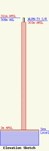
Site Elevation: 3 meters (10 ft) |
| Height of Structure: 296 meters (971 feet) |
| Overall Height Above Ground: 308 meters (1010 feet) |
| Overall Height Above Mean Sea Level: 311 meters (1020 feet) |
| WLRN-TV C/R Height Above Mean Sea Level: 303 meters (994 ft)
|
| Owner Info | The School Board of Miami-Dade County, Florida
172 NE 15th Street
Miami, FL 33132
(305) 995-2259
jlabonia@wlrn.org |
| Contact Info | The School Board of Miami-Dade County, Florida
172 NE 15th Street
Miami, FL 33132
(305) 995-2259
jlabonia@wlrn.org |
