|
|
Antenna Structure Registration 1041476 |
 |
Registration Info | Registration Number: 1041476 |
| File Number: A0723605 |
| FAA Study: 01-ASW-0236-OE |
| FAA Issue Date: 04/30/2001 |
| Status: Constructed |
| Date Constructed: 10/01/2002 |
| FAA EMI: N |
| NEPA: N |
Structure Info
| Structure Type: TOWER |
| Structure Coordinates: 29-14-40.0 N 98-44-28.0 W (NAD 83) |
| Structure Coordinates: 29-14-39.1 N 98-44-26.9 W (Converted to NAD 27) |
| Structure Address: .7 Km Se Of Int I-35 And Us 81 |
| Structure City: Atascosa, TX |
| Structure County: Bexar County |
| Painting & Lighting Info |
FAA Circular #: 70/7460-1K |
FAA Chapters: 3, 4, 5, 12 |
Remarks: Removed expiration date from determination. Scenario 1./jjs/case#635066 |
Remarks: PRIOR STUDY 91-ASW-0034-OE |
Remarks: Removed expiration date from determination. Scenario 1./jjs/case#635066 |
Remarks: PRIOR STUDY 91-ASW-0034-OE |
| Elevation Info |
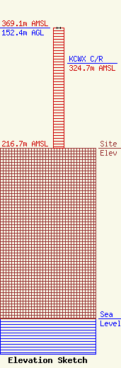
Site Elevation: 216.7 meters (711 ft) |
| Height of Structure: 152.4 meters (500 feet) |
| Overall Height Above Ground: 152.4 meters (500 feet) |
| Overall Height Above Mean Sea Level: 369.1 meters (1211 feet) |
| KCWX C/R Height Above Mean Sea Level: 324.7 meters (1065 ft)
|
| Owner Info | Educational Media Foundation
5700 West Oaks Blvd.
Rocklin, CA 95765
(916) 251-1600
|
| Contact Info | Shaw Pittman
2300 N Street, NW
Washington, DC 20037
David Oxenford
(202) 663-8000
|
