|
|
Antenna Structure Registration 1041960 |
 |
Registration Info | Registration Number: 1041960 |
| File Number: A1119646 |
| FAA Study: 2013-ASO-10851-OE |
| FAA Issue Date: 01/22/2014 |
| Status: Constructed |
| Date Constructed: 01/01/2006 |
| FAA EMI: N |
| NEPA: N |
Structure Info
| Structure Type: GTOWER |
| Structure Coordinates: 31-31-36.1 N 89-8-10.2 W (NAD 83) |
| Structure Coordinates: 31-31-35.5 N 89-08-10.0 W (Converted to NAD 27) |
| Structure Address: 2301 Hwy 29 South |
| Structure City: Laurel, MS |
| Structure County: Jones County |
| Painting & Lighting Info |
FAA Circular #: 70/7460-1F |
FAA Chapters: 3, 4, 5, 9 |
Remarks: PRIOR STUDY 1984-ASO-1820-OE |
Remarks: OM&L to remain the same as prior study = PAINT/RED LIGHTS |
Remarks: PRIOR STUDY 1984-ASO-1820-OE |
Remarks: OM&L to remain the same as prior study = PAINT/RED LIGHTS |
| Elevation Info |
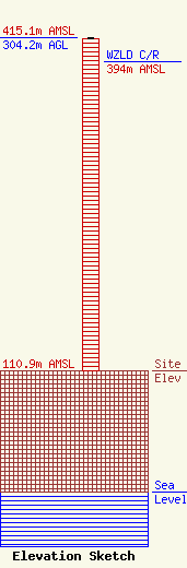
Site Elevation: 110.9 meters (364 ft) |
| Height of Structure: 303.2 meters (995 feet) |
| Overall Height Above Ground: 304.2 meters (998 feet) |
| Overall Height Above Mean Sea Level: 415.1 meters (1362 feet) |
| WZLD C/R Height Above Mean Sea Level: 394 meters (1293 ft)
|
| Owner Info | Vertical Bridge CC FM, LLC
750 Park of Commerce Dr.
Boca Raton, FL 33487
(561) 406-4015
fcc-faa@verticalbridge.com |
| Contact Info | Vertical Bridge CC FM, LLC
750 Park of Commerce Dr.
Boca Raton, FL 33487
Richard Hickey
(561) 406-4015
fcc-faa@verticalbridge.com |
