|
|
Antenna Structure Registration 1043280 |
 |
Registration Info | Registration Number: 1043280 |
| File Number: A0812694 |
| FAA Study: 2012-AEA-5137-OE |
| FAA Issue Date: 11/21/2012 |
| Status: Constructed |
| Date Constructed: 01/01/1982 |
| FAA EMI: N |
| NEPA: N |
Structure Info
| Structure Type: LTOWER |
| Structure Coordinates: 40-47-48.1 N 73-27-47.3 W (NAD 83) |
| Structure Coordinates: 40-47-47.7 N 73-27-48.9 W (Converted to NAD 27) |
| Structure Address: 1 Fairchild Ave |
| Structure City: Plainview, NY |
| Structure County: Nassau County |
| Painting & Lighting Info |
FAA Circular #: 70/7460-1K |
FAA Chapters: 3, 4, 5, 12 |
Remarks: PRIOR STUDY 1979-AEA-312-OE |
| Elevation Info |
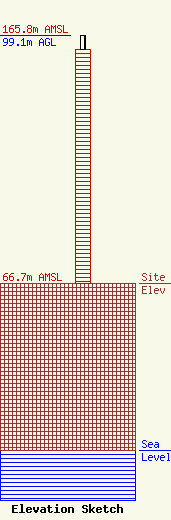
Site Elevation: 66.7 meters (219 ft) |
| Height of Structure: 93.7 meters (307 feet) |
| Overall Height Above Ground: 99.1 meters (325 feet) |
| Overall Height Above Mean Sea Level: 165.8 meters (544 feet) |
| Owner Info | COMMUNICATIONS LEASING INC
2551 S.W. 28TH TERRACE
FORT LAUDERDALE, FL 33312
(954) 327-9499
elliotg@bellsouth.net |
| Contact Info | COMMUNICATIONS LEASING INC
2551 S.W. 28TH TERRACE
FORT LAUDERDALE, FL 33312
(954) 327-9499
elliotg@bellsouth.net |
