|
|
Antenna Structure Registration 1043883 |
 |
Registration Info | Registration Number: 1043883 |
| File Number: A0717131 |
| FAA Study: 01-ASO-8531-OE |
| FAA Issue Date: 11/09/2001 |
| Status: Constructed |
| Date Constructed: 03/07/2011 |
| FAA EMI: N |
| NEPA: N |
Structure Info
| Structure Type: TOWER |
| Structure Coordinates: 35-1-32.9 N 85-4-24.7 W (NAD 83) |
| Structure Coordinates: 35-01-32.6 N 85-04-24.9 W (Converted to NAD 27) |
| Structure Address: 4100 Stratton Ln |
| Structure City: Collegedale, TN |
| Structure County: Hamilton County |
| Painting & Lighting Info |
FAA Chapters: NONE |
Remarks: PRIOR STUDY 96-ASO-0964-OE |
| Elevation Info |
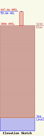
Site Elevation: 388 meters (1273 ft) |
| Height of Structure: 58.2 meters (191 feet) |
| Overall Height Above Ground: 59.4 meters (195 feet) |
| Overall Height Above Mean Sea Level: 447.4 meters (1468 feet) |
| W21BZ C/R Height Above Mean Sea Level: 0 meters (0 ft)
|
| Owner Info | SOUTHERN ADVENTIST UNIVERSITY
BOX 870 5055 HICKMAN DR
COLLEGEDALE, TN 37315-0870
(423) 236-2905
DWATER@SOUTHERN.EDU |
