|
|
Antenna Structure Registration 1045235 |
 |
Registration Info | Registration Number: 1045235 |
| File Number: A1114917 |
| FAA Study: 98-AGL-1880-OE |
| FAA Issue Date: 07/08/1998 |
| Status: Constructed |
| Date Constructed: 11/19/2001 |
| NEPA: N |
Structure Info
| Structure Type: GTOWER |
| Structure Coordinates: 42-54-16.3 N 89-33-21.3 W (NAD 83) |
| Structure Coordinates: 42-54-16.3 N 89-33-20.9 W (Converted to NAD 27) |
| Structure Address: 0.3 Km Se Of Int Of Observatory Rd And County Trunk A |
| Structure City: Montrose, WI |
| Structure County: Dane County |
| Painting & Lighting Info |
FAA Circular #: 70/7460-1J |
FAA Chapters: 3, 4, 5, 13 |
Remarks: PRIOR FAA 95-AGL-2722-OE |
| Elevation Info |
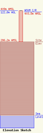
Site Elevation: 286.2 meters (939 ft) |
| Height of Structure: 121.9 meters (400 feet) |
| Overall Height Above Ground: 122.8 meters (403 feet) |
| Overall Height Above Mean Sea Level: 409 meters (1342 feet) |
| WSUM C/R Height Above Mean Sea Level: 403.5 meters (1324 ft)
|
| Owner Info | UNIVERSITY OF WISCONSIN BOARD OF REGENTS DBA WSUM RADIO
1860 VAN HISE HALL
MADISON, WI 53706
(608) 262-3662
gm@wsum.wisc.edu |
| Contact Info | UNIVERSITY OF WISCONSIN BOARD OF REGENTS DBA WSUM RADIO
333 East Campus Mall
Madison, WI 53715
(608) 262-9542
gm@wsum.wisc.edu |
