|
|
Antenna Structure Registration 1045602 |
 |
Registration Info | Registration Number: 1045602 |
| File Number: A0978442 |
| FAA Study: 98-ANE-0062-OE |
| FAA Issue Date: 03/30/1998 |
| Status: Constructed |
| Date Constructed: 02/01/2003 |
| FAA EMI: N |
| NEPA: N |
Structure Info
| Structure Type: TOWER |
| Structure Coordinates: 43-50-44.0 N 70-45-41.0 W (NAD 83) |
| Structure Coordinates: 43-50-43.7 N 70-45-42.8 W (Converted to NAD 27) |
| Structure Address: Western Peak Of Bald Mountain |
| Structure City: Baldwin, ME |
| Structure County: Cumberland County |
| Painting & Lighting Info |
FAA Circular #: 70/7460-1J |
FAA Chapters: 3, 4, 9, 13 |
Remarks: SUPPLEMENTAL NOTICE STATES STRUCTURE REACHED GREATEST HEIGHT ON 09/12/2001 |
Remarks: Removed expiration and final dates from determination. Scenario 2./jjs/case#635066 |
Remarks: SUPPLEMENTAL NOTICE STATES STRUCTURE REACHED GREATEST HEIGHT ON 09/12/2001 |
Remarks: Removed expiration and final dates from determination. Scenario 2./jjs/case#635066 |
| Elevation Info |
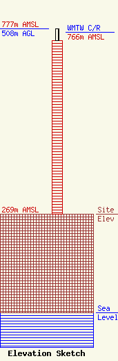
Site Elevation: 269 meters (883 ft) |
| Height of Structure: 474 meters (1555 feet) |
| Overall Height Above Ground: 508 meters (1667 feet) |
| Overall Height Above Mean Sea Level: 777 meters (2549 feet) |
| WMTW C/R Height Above Mean Sea Level: 766 meters (2513 ft)
|
| Owner Info | Hearst Properties Inc.
1800
Raleigh, NC 27602
(919) 839-0300
mprak@brookspierce.com |
| Info |
