|
|
Antenna Structure Registration 1047010 |
 |
Registration Info | Registration Number: 1047010 |
| File Number: A1255362 |
| FAA Study: 98-AGL-2256-OE |
| FAA Issue Date: 06/08/1998 |
| Status: Constructed |
| Date Constructed: 01/01/1985 |
| NEPA: N |
Structure Info
| Structure Type: TOWER |
| Structure Coordinates: 37-36-50.0 N 88-52-20.0 W (NAD 83) |
| Structure Coordinates: 37-36-49.8 N 88-52-19.8 W (Converted to NAD 27) |
| Structure Address: 2 Mi W |
| Structure City: Creal Springs, IL |
| Structure County: Williamson County |
| Painting & Lighting Info |
FAA Circular #: |
FCC Paragraph(s): 1, 3, 7, 16, 21 |
Remarks: OM&L TO REMAIN PAINT/RED LIGHTS AS PER PREVIOUS FAA 83GL2175. |
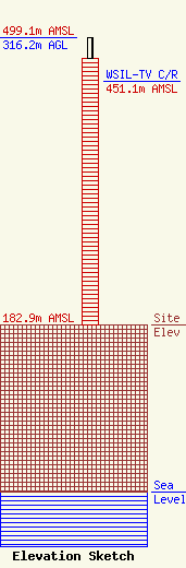
| Elevation Info |
Site Elevation: 182.9 meters (600 ft) |
| Height of Structure: 293.2 meters (962 feet) |
| Overall Height Above Ground: 316.2 meters (1037 feet) |
| Overall Height Above Mean Sea Level: 499.1 meters (1637 feet) |
| WSIL-TV C/R Height Above Mean Sea Level: 451.1 meters (1480 ft)
|
| Owner Info | Harrisburg TV License Company, LLC
1925 Century Park East
Los Angeles, CA 90067
(310) 277-3500
JeffreyM@es.tv |
| Contact Info | Allen Media Group Broadcasting
1925 Century Park East
Los Angeles, CA 90067
Dan Whealy
(319) 291-1206
dwhealy@allenmediabroadcasting.com |
