|
|
Antenna Structure Registration 1047894 |
 |
Registration Info | Registration Number: 1047894 |
| File Number: A0382967 |
| Status: Constructed |
| Date Constructed: 10/01/1997 |
| FAA EMI: N |
| NEPA: N |
Structure Info
| Structure Type: 2TA2 |
| Structure Coordinates: 40-39-15.0 N 122-31-16.0 W (NAD 83) |
| Structure Coordinates: 40-39-15.5 N 122-31-11.9 W (Converted to NAD 27) |
| Structure Address: Twr D - 12857 S Fork Mountain Rd |
| Structure City: Redding, CA |
| Structure County: Shasta County |
| Painting & Lighting Info |
FCC Paragraph(s): None |
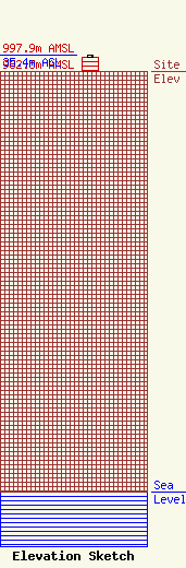
| Elevation Info |
Site Elevation: 962.5 meters (3158 ft) |
| Height of Structure: 30.5 meters (100 feet) |
| Overall Height Above Ground: 35.4 meters (116 feet) |
| Overall Height Above Mean Sea Level: 997.9 meters (3274 feet) |
| K35PG-D C/R Height Above Mean Sea Level: 982.5 meters (3223 ft)
|
| Owner Info | TARS, INC.
990970
Redding, CA 96099-0970
(530) 241-6025
|
| Contact Info | Schwaninger & Associates, P.C.
1331 H Street, NW, Suite 500
Washington, DC 20005
Ricahrd Hanno
(202) 347-8580
rhanno@sa-lawyers.net |
