|
|
Antenna Structure Registration 1048802 |
 |
Registration Info | Registration Number: 1048802 |
| File Number: A1310806 |
| FAA Study: 98-ASO-2078-OE |
| FAA Issue Date: 05/11/1998 |
| Status: Constructed |
| Date Constructed: 08/01/1954 |
| FAA EMI: N |
| NEPA: N |
Structure Info
| Structure Type: TOWER |
| Structure Coordinates: 34-16-18.0 N 79-43-33.0 W (NAD 83) |
| Structure Coordinates: 34-16-17.4 N 79-43-33.8 W (Converted to NAD 27) |
| Structure Address: 3430 North Tv Road |
| Structure City: Florence, SC |
| Structure County: Florence County |
| Painting & Lighting Info |
FAA Circular #: 70/7460-1J |
FAA Chapters: 3, 4, 5, 13 |
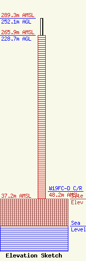
| Elevation Info |
Site Elevation: 37.2 meters (122 ft) |
| Height of Structure: 228.7 meters (750 feet) |
| Overall Height Above Ground: 252.1 meters (827 feet) |
| Overall Height Above Mean Sea Level: 289.3 meters (949 feet) |
| W19FC-D C/R Height Above Mean Sea Level: 48.2 meters (158 ft)
|
| Owner Info | Subcarrier Communications, Inc.
139 White Oak Lane
Old Bridge, NJ 08857
(732) 607-2828
kerri@subcarrier.com |
| Contact Info | Subcarrier Communications, Inc.
139 White Oak Lane
Old Bridge, NJ 08857
John Paleski
(732) 607-2828
kerri@subcarrier.com |
